Destinations in Sicily
AEOLIAN ISLANDS
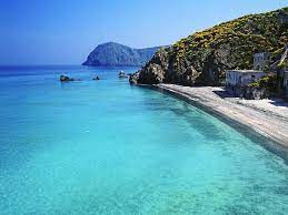
Italy's largest island, Sicily offers exceptional beaches, charming villages and towns, as well as an abundance of ancient ruins and archaeological sites. aces the warm waters of the Mediterranean. Throughout history, Sicily has been at the crossroad of cultures, landscapes and cuisine.
Sicily, Italian Sicilia, island, southern Italy, the largest and one of the most densely populated islands in the Mediterranean Sea. Together with the Egadi, Lipari, Pelagie, and Panteleria islands, Sicily forms an autonomous region of Italy.


Stromboli
Best Times: May - October
Stromboli is an island in the Tyrrhenian Sea, off the north coast of Sicily, containing Mount Stromboli, one of the four active volcanoes in Italy. It is one of the eight Aeolian Islands, a volcanic arc north of Sicily. Strabo writes that people believed that this is where Aeolus lived
Stromboli port: +39 090 986390
Wind forecast: Click here
Weather forecast: Click here
Moorings and berthings in Stromboli:
If you want to anchor, it is good to know that there are not many places where it will be possible to do so, the high depths of the waters hardly allow it. The most suitable place to anchor is in front of the beach of Ficogrande, in correspondence with the restaurant La Tartana, easily identifiable even from the sea. To the east of Punta Lena, in front of the clearly visible boats of the fishermen pulled ashore, the depths are around twenty meters. About 100 meters from the port of Ginostra, a rocky and irregular seabed of about twenty meters will allow you to drop anchor. There are no tourist ports on the island, during the summer a buoy camp, managed by Sabbienere with a transfer service, will allow you to leave the boat in total safety and enjoy the magical atmosphere that this island offers.


Lipari
Best Times: May - October
Lipari is the largest of the Aeolian Islands in the Tyrrhenian Sea off the northern coast of Sicily, southern Italy; it is also the name of the island's main town and comune, which is administratively part of the Metropolitan City of Messina.
Porto di Pignataro: +39 090 9880354
Website: Website
Rates: Click here for rates
Email: info@portopignataro.it
Wind forecast: Click here
Weather forecast: Click here
Moorings and berthings in Lipari:
Lipari is the central island of the Aeolian Islands and in the bay of Lipari there is a better chance of spending a night in the port, even in high season. The island has a marina, harbors, floating docks and many anchorages, where protection from all winds can be found. In Lipari we stop to do the shopping in the various supermarkets (with delivery service to the boat). Most of the landings develop on the eastern side of the island: Marina Lunga, Marina Corta and Pignataro. Without a doubt Lipari is an excellent starting point or stopping point during the sailing holidays around the wonderful Aeolian Islands. In Marina Lunga, so called the long bay of Lipari, there are various private floating docks, which offer water services, electricity, mooring for dead bodies, mooring assistance. In the northern part of the bay, there is the Port of Pignataro, a private marina with all services and also protected from the sirocco. In the historic center of the town of Lipari there is Marina Corta, an extremely picturesque port, but intended only for small local boats.
Bays and anchorages in Lipari at the Aeolian Islands
In Lipari, you can anchor in Vinci, a swim near the Arch and the Faraglioni of Lipari or in Vallemura, a large bay with a scenic black sand beach, narrow with cliffs overlooking the beach. From the boat it is a spectacle of wild nature. Larger and wider is the bay of Porticello, with the pumice stone quarries in sight: the mountain is drawn in white and the contrast with the blue of the sea is a curious play of colors.


Salina
Best Times: May - October
Salina is one of the Aeolian Islands north of Sicily, southern Italy. It is the second largest island in the archipelago. Salina is divided between three comuni: Santa Marina on the eastern coast, Malfa to the north, and Leni to the south-west. From Leni down towards the sea is the village of Rinella.
Porto di Santa Marina: +39 090 9022167
Rates: Click here
Website: WEBSITE
Email: info@marinadisalina.com
Wind forecast: Click here
Weather forecast: Click here
Moorings and berthings in Salina:
Salina is the second largest island of the archipelago, Nautical map Salinas separated from Lipari by a 2km gully, where the depth does not exceed 400m.
Centrally located, it assumes a strategic role; ideal reconnaissance point for those who wish to tour the islands without giving up a well-equipped tourist dock and a town that can satisfy any type of need.
The island is easily identifiable due to the two majestic mountains, Monte Fossa delle Felci and Monte Porri, which respectively represent the first and third highest peak of the Aeolian Islands. Salina has a coastal morphology of extraordinary beauty and one cannot fail to take a tour of the island to see: the bay of Pollara which with the Balate area, the stack and the natural rock arch constitute the submerged part of the extinct crater where the homonymous town rests; the beautiful lake of Lingua, divided from the sea by a thin strip of land; the small town of Malfa with its typical houses that dominate the promontory; the small fishing village of Rinella that from its bay, where the sea boils, climbs along a steep slope and much more will enchant you and create in you the desire to return.
On the island, which has a circumnavigation of 13 miles, there are the ports of:
Santa Marina and Rinella
for the landing of ferries and hydrofoils, a tourist dock also in Santa Marina, a buoy field in Rinella and the landings of:
Punta Lingua, Scalo Galera and Capo Faro no longer accessible as it was destroyed by storm surges.


Vulcano
Best Times: May - October
Vulcano or Vulcan is a small volcanic island belonging to Italy in the Tyrrhenian Sea, about 25 km north of Sicily and located at the southernmost end of the seven Aeolian Islands.
Porto di Levante: +39 333 3774862
Website: WEBSITE
Email: rdservice.srls@gmail.com
Wind forecast: Click here
Weather forecast: Click here
Moorings and berthings in Vulcano:
Immediately north of the commercial port of Vulcano, located in the sheltered Baia delle Acque Calde, in 2010 there is Marina di Vulcanello, a comfortable and efficient tourist port that offers guest owners moorings and berths on a floating dock or buoy field.


Filicudi
Best Times: May - October
Filicudi is one of eight islands that make up the Aeolian archipelago, situated 56 km northeast of the island of Sicily, southern Italy. It is a frazione of the comune of Lipari.
Pontile Filicudi Porto: Marina di Filicudi Tel. +39 3286559228
Campo boe Pecorini: La Boa Tel. +39 3407667999
Campo boe Pecorini: I Delfini Tel. +39 3401484645
Website: WEBSITE
Wind forecast: Click here
Weather forecast: Click here
Moorings and berthings in Filicudi:
Navigating the waters of the archipelago, which rapidly sink over two thousand meters, is a unique experience that will totally satisfy you, but navigating the Aeolian Islands, without paying attention to the dangers that lie there, can reserve unpleasant surprises.
Being volcanic in nature, the coasts, in many places, are surrounded by rocks and shoals near the shore. Filicudi is mainly made up of two reliefs: Fossa delle Felci, 773 m high, whose northern slopes are steep and uninhabited, while the southern and eastern sides appear cultivated and inhabited; the other relief is that of Capo Graziano, 174 m high, joined to the previous one by a flat isthmus that from the sea makes them appear as two independent islands.
The seabed around the island is very deep, with the exception of the north and north-western part, where it is advisable to sail at a safe distance from the coast due to the presence of rocks.
Another point where you should pay particular attention is the one corresponding to the south-east end of Capo Graziano, where a 2.5 m shoal makes navigation dangerous especially in rough seas. On the north-eastern side it is possible to avoid dangers between the Canna di Filicudi, known for its small rocks and for its wonderful depths that do not exceed 17 m in depth. The seabed adjacent to the port area of Filicudi Porto allows anchoring, although considerable attention must be paid to submarine cables and weather conditions because it is a point very exposed to the winds of the 1st quadrant and, in part, also to the siroccal ones.


Alicudi
Best Times: May - October
Alicudi is the westernmost of the seven islands that make up the Aeolian archipelago, a volcanic island chain north of Sicily. The island is about 40 km west of Lipari, has a total area of 5.2 km², and is roughly circular.
Alicudi Porto
Wind forecast: Click here
Weather forecast: Click here
Moorings and berthings in Alicudi:
The island of Alicudi can be reached by tender. The small artificial docking can be used by the ferries only, and therefore there is no possibility of refilling the water tank or connecting to the electrical power.
There is a small jetty at the island's main port of Scalo Palomba, with depths of around 2.0 metres towards the end. However, space here is very limited and most yachts will need to anchor off. Depths drop off quite quickly and you will be anchoring in 10.0 – 15.0 metres. Needless to say, the island should only be visited in settled weather.


Panarea
Best Times: May - October
Panarea is the smallest of the seven inhabited Aeolian Islands, a volcanic island chain in north of Sicily, southern Italy. It is a frazione of the comune of Lipari.
Porto PanareaTel. +39 0565 912191
Wind forecast: Click here
Weather forecast: Click here
Moorings and berthings in Panarea:
The island of Panarea, the smallest of the Aeolian Islands, is located north-east from the promontory of Milazzo, about 3km long and 2km wide, covering an area of 3.3kmq spreading out in a circumference of 5miles.
The island is crossed by a ridge that divides it from north to south and reaches its apex with Pizzo del Corvo (421m) on which an iron cross is clearly visible. The inhabited area extends on the east and south-west slopes, where the morphology of the territory is more gentle, leaving room for timid slopes at times flat. The northern and western side is rocky, crossed by steep cliffs, in the coastal strip the high walls make landing operations difficult, if not impossible. The island does not have a safe harbor, the closest is 11.5 miles from Lipari port or 14 miles from the eastern port of Vulcano.
There are no particular dangers in navigating near Panarea, obviously at a safe distance from the coast. Pay particular attention if you are sailing near Basiluzzo, Lisca Bianca, Bottaro and Dattilo, where there are rocks on the water and numerous shoals. Half a mile south-east of Panarea are the Le Formiche rocks (38 ° 37.55 ′ - N 015 ° 05.14 ′ E) hardly visible, red sector for those who sail at night.
Pay particular attention to the stretch. From a marine point of view, the western side of Panarea offers good shelters from the winds coming from the north and west thanks to the numerous coves on the side.
The recommended anchoring points are:
Cala Junco
Baia Milazzase
Cala della Nave
Scalo Ditella
Basiluzzo
Lisca Bianca
Dattilo Bottaro
Lisca Nera
Panarelli e le Formiche